


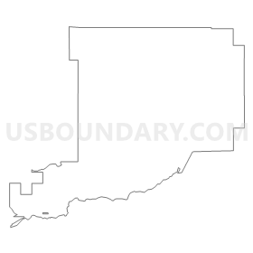
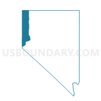
Precinct No. 7412, Washoe County, Nevada
About
Outline
Summary
| Unique Area Identifier | 616120 |
| Name | Precinct No. 7412 |
| County | Washoe County |
| State | Nevada |
| Area (square miles) | 222.37 |
| Land Area (square miles) | 222.13 |
| Water Area (square miles) | 0.24 |
| % of Land Area | 99.89 |
| % of Water Area | 0.11 |
| Latitude of the Internal Point | 39.70010430 |
| Longtitude of the Internal Point | -119.34468000 |
Maps


Graphs
Select a template below for downloading or customizing gragh for Precinct No. 7412, Washoe County, Nevada


Neighbors
Neighoring Voting District (by Name) Neighboring Voting District on the Map
- CHURCHILL PRECINCT 17, Churchill County, NV
- Precinct 12, Storey County, NV
- Precinct 13, Storey County, NV
- Precinct 14, Storey County, NV
- Precinct 15, Storey County, NV
- Precinct 8, Storey County, NV
- Precinct No. 40-FERNLEY #14, Lyon County, NV
- Precinct No. 6309, Washoe County, NV
- Precinct No. 6315, Washoe County, NV
- Precinct No. 6316, Washoe County, NV
- Precinct No. 7411, Washoe County, NV
- Precinct No. 7413, Washoe County, NV
- Precinct No. 7423, Washoe County, NV
- Precinct No. 9400, Washoe County, NV
- Precinct No. 9405, Washoe County, NV
- Precinct No. 9406, Washoe County, NV
- Precinct No. 9408, Washoe County, NV
- Precinct No. 9411, Washoe County, NV
- Precinct No. 9412, Washoe County, NV
- Precinct No. 9413, Washoe County, NV
- Precinct No. 9414, Washoe County, NV
- Precinct No. 9415, Washoe County, NV
- Precinct No. 9422, Washoe County, NV
- Precinct No. 9423, Washoe County, NV
- Precinct No. 9424, Washoe County, NV
- Precinct No. 9425, Washoe County, NV
Top 10 Neighboring County Subdivision (by Population) Neighboring County Subdivision on the Map
- Warm Springs-Truckee Canyon CCD, Washoe County, NV (52,378)
- Fernley CCD, Lyon County, NV (19,519)
- Pyramid Lake CCD, Washoe County, NV (1,654)
- Clark CCD, Storey County, NV (1,123)
- Carson Sink CCD, Churchill County, NV (29)
Top 10 Neighboring Place (by Population) Neighboring Place on the Map
Top 10 Neighboring Unified School District (by Population) Neighboring Unified School District on the Map
- Washoe County School District, NV (421,407)
- Lyon County School District, NV (51,980)
- Churchill County School District, NV (24,877)
- Storey County School District, NV (4,010)
Top 10 Neighboring State Legislative District Lower Chamber (by Population) Neighboring State Legislative District Lower Chamber on the Map
- Assembly District 32, NV (80,177)
- Assembly District 38, NV (66,836)
- Assembly District 35, NV (51,108)
Top 10 Neighboring State Legislative District Upper Chamber (by Population) Neighboring State Legislative District Upper Chamber on the Map
- Washoe County Senatorial District 2, NV (136,694)
- Central Nevada Senatorial District, NV (113,138)
- Capital Senatorial District, NV (102,155)
Top 10 Neighboring 111th Congressional District (by Population) Neighboring 111th Congressional District on the Map
Top 10 Neighboring Census Tract (by Population) Neighboring Census Tract on the Map
- Census Tract 9601.01, Lyon County, NV (10,653)
- Census Tract 9506, Churchill County, NV (5,359)
- Census Tract 35.01, Washoe County, NV (4,205)
- Census Tract 9702, Storey County, NV (4,010)
- Census Tract 9601.03, Lyon County, NV (1,716)
- Census Tract 9402, Washoe County, NV (1,650)
Top 10 Neighboring 5-Digit ZIP Code Tabulation Area (by Population) Neighboring 5-Digit ZIP Code Tabulation Area on the Map
- 89434, NV (25,416)
- 89406, NV (24,772)
- 89408, NV (19,626)
- 89510, NV (1,685)
- 89442, NV (1,118)
- 89424, NV (341)